- Description
- Details
- Map
04 Piz Quattervals
Schweizerischer Nationalpark
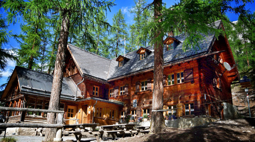
 - A challenging ascent of the highest peak that lies entirely within the National Park.
From 2500 m altitude upwards there is no visible trail; alpinists must choose their own route, bearing in mind that they may only pass through the Cluozza and Valletta valleys on their approach to Piz Quattervals. Other routes are not permitted. Danger of rockfall in mid and late summer (helmet recommended).
Particularities
Besides Munt la Schera, the only peak lying completely within the Park that is accessible to visitors. Overnight stay possible in Chamanna Cluozza.
Please note that breakfast at the Cluozza hut is served at dusk at the earliest. This in order to protect the animals from early disturbances.
04 Piz Quattervals
Difficulty
white-blue-white (alpine route) / difficult
The descent from Fuorcla Val Sassa is in steep scree, the path is only partially visible.
Arrival
See Route 07 or reverse Route 08 (incl. hike to the starting point Chamanna Cluozza)
Season
July, August, September, OctoberRoute-information
- Length
- 5.00 km
- Vertical heigth
- 1400 m
- Time required
- 5 hours
- Level technique
- Hard
- Level condition
- Hard
Arrival
- Starting point
- Chamanna Cluozza. Anreise siehe Route 07 oder umgekehrte Route 08 (Altitude: 1882 m)
- Destination
- Piz Quattervals (Altitude: 3165 m)
Infrastructure
- Picnicplace
Links
The offer is suitable for
- Adults
- Children >12 years
- 50+
- Groups
Contact
NationalparkzentrumUrtatsch 2
7530 Zernez
Tel. +41 (0)81 851 41 41
Mobile -
www.nationalparkzentrum.ch